‘The study of geography is about more than just memorising places on a map. It’s about understanding the complexity of our world’ Barack Obama, former US President
Geography is the study of our Earth’s landscapes, its people, places and environments. It is, quite simply, about the world in which we live. Our aim at Westhoughton High School is to develop a sense of place and to develop an awareness of a selection of contrasting physical and human environments. Geography gives an insight into the relationships between people and the environment and how each affects the other, and to comprehend the concept of a sustainable development. Geography enables students to foster a sympathetic understanding of some of the major issues of social concern such as social challenge and urban opportunities.
We aim to develop skills of critical enquiry as well as a firm understanding of concepts through a variety of key questions. The opportunity for fieldwork and practical experience is seen as an important part of the learning experience to bring the concepts that we study to life and the department is committed to providing a curriculum that involves work at home and abroad.
We encourage all pupils to appreciate how actions and decisions made at a local level can have global implications; as a consequence, there are frequent, lively discussions on themes as varied as the management and conservation of extreme environments, to the creation of sustainable communities in modern cities. We believe in the importance of this discussion and understanding in order to equip our next generations to make informed decisions for our community, country and planet.
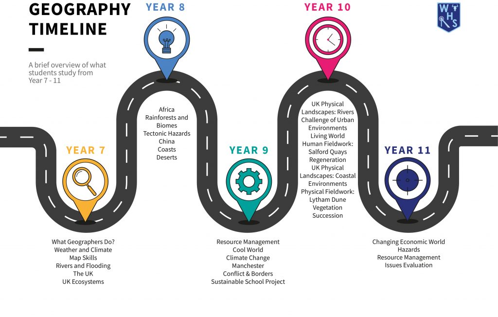
Please see parental overview of the course in KS3 and KS4 below.
Key Stage 3
Year 7 | Autumn 1 | Autumn 2 | Spring 1 | Spring 2 | Summer 1 | Summer 2 |
Topics Studied |
Geographical Skills
Students develop skills in the use of OS maps and gain experience of viewing images and maps from different perspectives to be able to understand landforms in multiple perspectives. |
What is Britain?
Students explore the cultural, geological, historical and political makeup of the British Isles. Students develop a geographical understanding of the British Isles at a variety of scales. |
Crumbling Coasts
Students begin their journey into Physical processes. We feel that this is the most relatable environment to begin our study of physical processes as most students will have first-hand experience of a coastal environment. |
Paradise Lost
Students explore the impact of tourism on economies of contrasting economic development, with a historical look at the UK, sustainable & community tourism and the growth of dark tourism. |
Planet People
Students discover the growth of human population over time and introduces the threshold vocabulary that will be essential for topics covered later in years 8 & 9. Issues of population are explored in countries of contrasting wealth like the UK, China & India. |
|
Skills and Key Knowledge Taught |
Map skills- countries in the BI/ UK
OS map symbol Scale and distance Map design Layer mapping Grid references Physical, Human and Environmental Concepts |
Skills focus –
Space, map, enquiry, fieldwork, Field sketching Enquiry/report writing Aboriginal Britain Rock formation Model making |
Skills focus – Map, OS maps.
Sequencing Erosion Weathering Hydraulic action Abrasion Corrasion Solution Cave, arch, stack, stump Fetch Constructive and destructive waves |
Skills focus – space, map, enquiry, fieldwork.
Butler Model Ecotourism HIC/ LIC Tourist/Tourist NEE GDP Community tourism Sustainable Social/Economic/ Environmental Multiplier effect Spiral of decline |
Skills focus – graphing, extended writing.
GDP Development HDI Population Pyramid Distribution Ageing Population Overpopulation Globalisation Economic growth Superpower 1-2-4 problem Little Emperors |
|
Links for Support/ Help at Home |
|
Year 8 | Autumn 1 | Autumn 2 | Spring 1 | Spring 2 | Summer 1 | Summer 2 |
Topics Studied |
Disappearing World
Students explore how human action is governed by the environment and how we interact with our own planet. Students explore adaptations to varying biomes and the cultures that exist within these regions, the challenges they face and the opportunities they present. |
Disappearing World
Students build to their knowledge in Spring 1, students build their ability to compare and contrast biomes as the unit progresses.
Our Developed World Students study the issues affecting a city in a High-Income Country (HIC) contrasting the past to the present and potential issues in the future. Our city to focus on is Manchester. |
Rapid Rivers
Students build on the physical processes from Crumbling Coasts by learning about the processes of erosion and how they link to landforms. |
The Awesome Arctic
a regional case study of the human and physical geography of the Arctic Circle, its climate, culture, opportunities and challenges, with a focus on Scandinavia and Russia |
Global Crossroads
Students will learn the climate, culture, human and physical Geography of the Middle East and the issues facing this diverse region. |
|
Skills and Key Knowledge Taught |
Skills focus –
Climate graphs Evaluation Map skills Essay writing skills Food Web Abiotic Food Chains Aspect Ecosystem Altitude Biomes Latitude Global Biotic Small scale Sustainable Deforestation Stewardship Conservation Distribution Adaptation |
Skills focus –
Empathy Extended writing/justification of points of view. Urbanisation Megacity Infrastructure Migration in a variety of scales Push and pull factors Amenities Sanitation Cholera Hygiene |
Skills focus –
Sequencing/OS maps/fieldsketching Erosion, transport and depositional processes Water cycle Drainage basins Landforms of erosion: Waterfalls. |
Skills focus – graphical, map, contrast.
Latitude Extreme environment Biome Climate Arctic Circle Culture Traditions Opportunities and challenges Adaptation Sustainability Stewardship |
Skills focus –
Compare & Contrast Graphs/maps Migration Climate Vegetation Adaptation Culture Conflict Slavery |
|
Links for Support/ Help at Home |
|
Year 9 | Autumn 1 | Autumn 2 | Spring 1 | Spring 2 | Summer 1 | Summer 2 |
Topics Studied |
Restless earth
Students explore the processes and products of earth forces. Students explore the links between the 3 disciplines in geography i.e., when does a natural event become a natural hazard? Earthquakes, Volcanoes, Tsunami, Supervolcanoes and hotspots. How and why do people choose to live in these regions? |
Restless Earth continued and then Our Developing World
Students complete the learning Restless Earth and then begin to explore the issues facing citizens of cities across LIC/NEE countries. They will look at how people find ingenious ways to survive and improve their quality of life. |
Our Developing World
Students explore mathematical, map and graph skills to develop the understanding of the measures and the means of calculation/ variety of ways data can be represented. |
On Thick Ice
Students further explore the natural processes of Glacial erosion with a reflective look back to What is Britain and the learning about our Ice age and Paradise lost and the tourism opportunities. |
The UK today
Students explore elements of all three Geographical disciplines relating to the UK. This ranges from food and energy security to extremes of weather, global warming, HS2 and levelling up. |
Geographical Skills
A synoptic look back at the Key stage 3 learning journey through an extended study of concepts and decision making activity. |
Skills and Key Knowledge Taught |
Skills focus –
Sequencing Extended writing Conservative plate margin Constructive plate margin Destructive plate margin Earthquake Immediate responses Long-term responses Plate margin Planning Prediction |
Primary effects
Protection Secondary effects Tectonic hazard Tectonic plate Volcano Economic impact Environmental impact Migration in a variety of scales Push and pull factors Amenities Sanitation Cholera Hygiene |
Skills focus –
Graph/map, empathy, place, scale. Modelling Sketching Map skills Role Play Calculations Conversions Development HDI GDP |
Skills focus –
Sketching Sequencing Process & product Glacial processes of erosion and landforms of erosion: Corries, Aretes, U shaped valleys |
Extreme weather
Brexit/independence Northern Powerhouse HS2 North/South Divide |
Skills focus –
Justify, teamwork, evaluation and management strategies |
Links for Support/ Help at Home |
|
Key Stage 4
Year 10 | Autumn Term 1 | Autumn Term 2 | Spring 1 | Spring 2 | Summer 1 | Summer 2 |
Topics Studied in AQA GCSE Geography |
Physical Landscapes in the UK- River Landscapes
Students study the features of the river valley, erosional, transportation and depositional processes and landforms focusing on the River Tees; Students learn of the challenges of flooding and strategies used to mitigate it. |
The Challenge of Resource Management Students explore the UK issues with food, water and energy – the journey up to now and what the future holds.Global distribution of the fundamental resources and the issues worldwide of supply and demand; focus shifts towards the energy challenge and what the 21st Century will demand. |
The Living World
Students learn of ecosystems and food webs, locally and globally. Students complete an enquiry into the Tropical Rainforest Ecosystem, and the challenges it faces balancing the opportunities it creates with the preservation of the ecosystem. Students will focus on the Amazon rainforest in South America contrasted with cold environments and ecosystems. |
The Living World
Students continue with the content from Spring 1. |
Physical Landscapes in the UK – Glacial Landscapes in the UK
Students learn to identify the features of glaciated upland landscapes, processes which formed them, focusing in on the Lake District region. The impact of tourism and the issues it creates are also examined. |
Fieldwork
The students undertake two field visits either at Blencathra field centre or Malham for a river investigation as part of the requirement to study the physical component. They then evaluate the impact of tourism and the issues it creates are examined in the second piece of fieldwork, which involves all students collecting data off site in the village of either Grasmere or Ambleside. |
Skills and Key Knowledge Taught | Landscape
Abrasion Arête Bulldozing Conservation Corrie Drumlin Erratics Freeze-thaw weathering Glacial trough Hanging valley Land use conflicts Moraine Outwash Plucking Pyramidal peak Ribbon lake Rotational slip Till Truncated spur |
Agribusiness
Carbon footprint Energy mix Food miles Fossil fuel Local food sourcing Organic produce Resource Management Aeroponics Biotechnology Famine Food insecurity Food security Hydroponics Irrigation Permaculture Sustainable development Sustainable food supply Undernutrition Urban farming ‘Grey’ water Groundwater management Over-abstraction Sustainable development Sustainable water supply |
Abiotic
Biotic Decomposer Ecosystem Food chain Food web Nutrient cycling Global ecosystem Producer Photosynthesis. Biodiversity Commercial farming Debt reduction Deforestation Ecotourism Logging Mineral extraction Selective logging Soil erosion Subsistence farming Sustainability Fragile environment Infrastructure Permafrost Polar Tundra |
Urbanisation
Megacity Migration in a variety of scales Push and pull factors Amenities Sanitation Cholera Hygiene Infrastructure Brownfield site Economic opportunities Greenfield site Mega-cities Migration Natural increase Pollution Rural-urban fringe Sanitation Social deprivation Social opportunities Squatter settlement |
AO3: Apply knowledge and understanding to interpret, analyse and evaluate geographical information and issues to make judgements (35%, including 10% applied to fieldwork context).
AO4: Select, adapt and use a variety of skills and techniques to investigate questions and issues and communicate findings (25%, including 5% used to respond to fieldwork data and context. |
Links for Support/Help at Home |
|
Year 11 | Autumn Term 1 | Autumn Term 2 | Spring 1 | Spring 2 | Summer 1 | Summer 2 |
Topics Studied in AQA GCSE Geography |
The Economic World
Students study the development measures and indicators such as HDI/GNP. They explore the journey of development through the case study of Nigeria, with a particular focus on the industry, the role of TNC’s, Environmental issues and solutions. |
The Economic World continued then Natural Hazards
Students study tectonic hazards with a closer study of volcanoes, how they impact humans living alongside them, preparations for an eruption and responses to an event. Students draw comparisons between a Low-Income Country and a High-Income Country. Students explore weather hazards and global circulation of the air we breathe. How tropical storms form, and climate change. |
Restless Earth continued then
Urban Issues and Challenges with PPE & Revision Opportunities and challenges created by rapid urban growth, the impact on a Newly Emerging Economy and the solutions to the effects. Focus based around Nigeria and Brazil. Students study the changing UK cities and their shift towards more sustainable urban living concentrating on issues for the future – waste recycling and management, traffic and congestion, water conservation, green spaces and energy conservation. Focus based more locally on the city of Manchester. Students begin revision for their PPEs and retrieval of the course to date. |
Urban Issues continued then Issue Evaluation/ Revision-focus
The exam board release material with a brief period for students to study. |
Issue Evaluation and Class-specific revision Revision foci will differ between groups and students to ensure their assessment data is used to direct teaching and independent learning. |
Exams undertaken |
Skills and Key Knowledge Taught |
Birth rate
Commonwealth Death rate De-industrialisation Demographic Transition Model Development Development gap European Union Fairtrade Globalisation Gross national income (GNI) Human Development Index (HDI) Infant mortality Intermediate technology International aid Life expectancy Literacy rate Microfinance loans North-south divide (UK) Post-industrial economy Science and business parks Service industries (tertiary industries) Trade Transnational Corporation (TNC |
Hazard risk
Natural hazard Conservative plate margin Constructive plate margin Destructive plate margin Earthquake Immediate responses Long-term responses Monitoring Plate margin Planning Prediction Primary effects Protection Secondary effects Tectonic hazard Tectonic plate Global atmospheric circulation Social impact Tropical storm (hurricane, cyclone, typhoon) Climate change Mitigation Orbital changes Quaternary period |
Urbanisation
LIC/NEE/HIC Rural – Urban Migration Urban – Rural Migration Push factors Pull factors Cholera Favela Sanitation Slums of hope/despair Pacification NGO |
An accumulation of all content, skills and key terminology. | An accumulation of all content, skills and key terminology. | |
Links for Support/ Help at Home |
|